Photographing Mungo National Park
About Mungo National Park
Mungo National Park, in south-western New South Wales, protects part of the ancient Lake Mungo basin within the Willandra Lakes Region World Heritage Area. For photographers it is one of Australia's most distinctive arid landscapes: pale and ochre lunettes, sculpted erosion, mobile sand dunes, dry lakebed, mallee and belah woodland, big skies, wildlife and pastoral buildings all occur within a comparatively compact area.
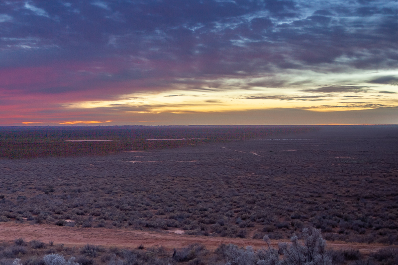
The landscape is visually dramatic, but its importance goes far beyond scenery. Aboriginal people have lived in the Willandra Lakes region for more than 40,000 years. Mungo Lady and Mungo Man were buried on the shores of the former lake more than 42,000 years ago. Mungo is jointly managed with the Ngyiampaa, Mutthi Mutthi and Southern Paakantyi/Paakantji people, and photographers should treat the lunettes and any cultural material with particular respect.
The best-known formations are the Walls of China, part of the long crescent-shaped lunette on the eastern side of the former lake. Wind and water erosion have exposed layers of sand and clay, creating ridges, pinnacles, folds and textures that change markedly with low-angle light. Access onto the lunette itself is restricted to guided tours; the public viewing platform provides an unrestricted overview.
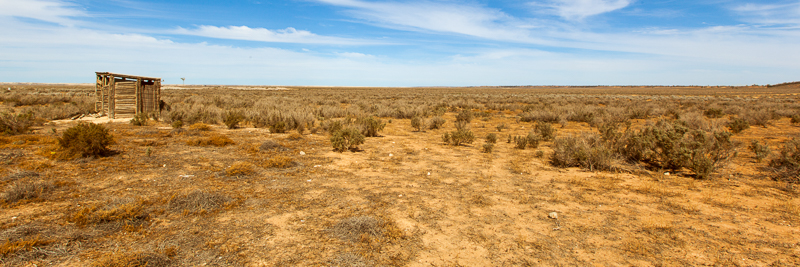
Mungo rewards a slower visit. The classic formations are only one part of the photographic story. The 70 km self-guided drive crosses the old lakebed and links Red Top, mallee country, Vigars Well dunes, pastoral sites and woodland. Around the Visitor Centre, the historic Mungo Woolshed and Shearers' Quarters add architectural and documentary subjects.
Cultural landscape and photographic responsibility
This is not simply a geological location. Remains, artefacts, hearths and other evidence can be culturally sensitive and are protected. Stay on permitted routes, do not disturb or collect material, and follow ranger and Traditional Owner guidance. The Aboriginal-guided Mungo lunette tour is strongly recommended: it provides lawful access onto the lunette while placing the landscape in its cultural context.
Viewpoints
1. Walls of China viewing platform
This is the principal independent viewpoint over the Mungo lunette. The boardwalk and platform look across the eroded formations and are particularly effective when low sun gives the ridges side-light and shadow. A 70–200mm lens is valuable for isolating patterns and compressing successive ridges; a wider lens can include the platform-side vegetation and sky to explain the scale of the country.
2. Mungo lunette – guided access
The two-hour Aboriginal-guided lunette tour allows closer views of the sculpted landscape. Photographically, this is where smaller erosion forms, textures, colour transitions and layered compositions become most apparent. Access is guided-only, so photography must fit around the cultural interpretation and group movement rather than treating the tour as an unrestricted photo workshop.
3. Red Top lookout and boardwalk
Red Top provides another elevated view across Lake Mungo and the eroded lunette. It is useful for broader landscape compositions and for comparing the warm eroded formations with the pale lakebed and blue sky. The changing direction of light makes it a useful counterpoint to the Walls of China viewpoint.
4. Vigars Well and mobile dunes
Vigars Well gives access to mobile sand dunes and a more minimalist desert vocabulary: wind ripples, dune crests, footprints, sparse vegetation and large areas of negative space. Low-angle light is ideal for revealing texture. Keep compositions simple and look for repeating curves and isolated plants.
5. Mungo Woolshed and Visitor Centre precinct
The historic woolshed is an excellent architectural and documentary subject. Work with the repeating timber structure, corrugated surfaces, doorways, shearing details and the contrast between the building and the open landscape. A standard zoom is generally more useful than an ultra-wide lens because it controls perspective while still allowing environmental views.
6. Zanci Pastoral Loop
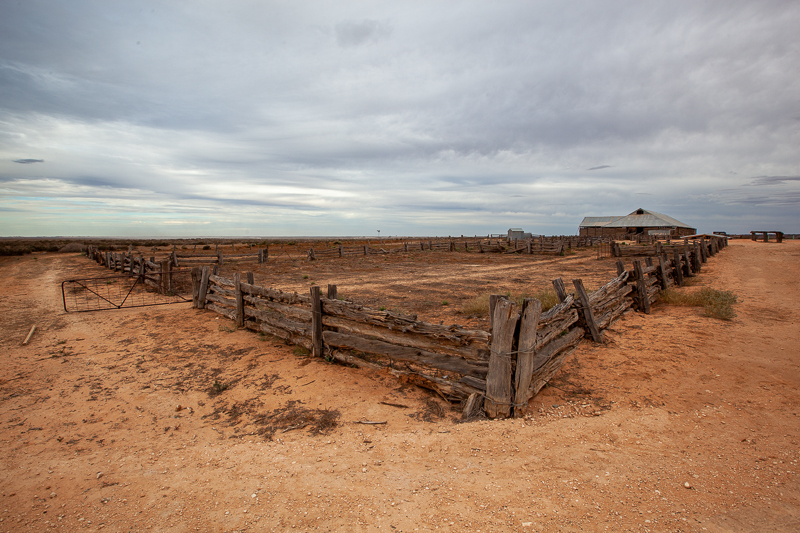
The short Zanci loop adds pastoral ruins, old station-country context, woodland and wildlife. It works well when you want the gallery to tell the broader Mungo story rather than consist only of lunette photographs.
7. Lakebed and mallee country
The drive across the former lake provides understated but important images: immense flat space, wheel tracks, isolated trees, mallee, dust, cloud shadows and distant lunettes. These are strong establishing photographs and often communicate Mungo's scale better than close views alone.
Other Things to Look Out For
Other things to look out for
- Western red kangaroos and emus: common large subjects, especially in softer morning and late-afternoon light.
- Birds of prey: wedge-tailed eagles, whistling kites and brown falcons may be seen over the open country.
- Mallee and belah woodland: useful for environmental detail, texture and a visual break from the bare lakebed.
- Weather: storm fronts, virga, dust and broken cloud can transform otherwise stark country.
- Night sky: the remote setting and open horizons make the park attractive for stars and Milky Way compositions where overnight access and conditions allow.
- Pastoral details: timber, corrugated iron, fencing and station remnants complement the deep-time landscape.
How I would photograph Mungo
I would carry the Canon 5DSR, 16–35mm and 24–70mm zooms, plus a 70–200mm telephoto. The telephoto is unusually important here because the public viewpoints are separated from the formations and compression helps organise the lunette. A sturdy tripod is useful around sunrise, sunset and for night work, but on a guided tour I would keep the kit compact and mobile.
Techniques
- Telephoto compression: stack eroded ridges and remove empty foreground.
- Side-light: use low sun to reveal the relief of dunes and lunettes.
- Panoramas: the lakebed and long lunette suit multi-frame panoramas; level the tripod carefully and leave generous overlap.
- Foreground / middle / far: use vegetation, lakebed, lunette and sky as successive layers.
- Minimalism: Vigars Well dunes suit isolated plants, curves and negative space.
- Exposure bracketing: useful around sunrise/sunset where bright sky and shaded formations exceed a single exposure.
- Astrophotography: scout foregrounds in daylight and avoid disturbing cultural sites after dark.
Nearby Locations
Mungo is remote, so “nearby” is relative. The most useful additions are generally stops made while approaching or leaving the park rather than quick side trips.
- Willandra Lakes World Heritage landscape: the wider dry-lake system provides the regional context for Mungo's geology and cultural history.
- Balranald: a practical eastern gateway and useful base for photographing the Murrumbidgee/Murray–Darling outback transition.
- Wentworth: west of Mungo, with the Darling–Murray confluence, river red gums and historic river-town subjects.
- Mildura: the major service centre for many visitors approaching from Victoria, with Murray River landscapes, heritage and supplies before the remote drive.
- Pooncarie: a small Darling River settlement that can form part of a northern approach or wider outback itinerary, subject to road conditions.
Because unsealed-road conditions can change rapidly, do not build a photographic itinerary around cross-country shortcuts without checking the relevant council road reports immediately before travel.
Location
Mungo National Park is in south-western NSW in the Murray–Riverina region, within the Willandra Lakes Region World Heritage Area. The main visitor hub is Mungo Visitor Centre beside Mungo Woolshed and the Shearers' Quarters.
Approximate Visitor Centre coordinates: 33.75°S, 143.13°E. Use current NPWS mapping and road signs for navigation rather than relying solely on a coordinate, because there are several remote approach roads and conditions vary.
There is limited mobile coverage in the park. Download maps and road-condition information before leaving the major towns.
Apple Map – Location and Nearby Photographic Locations
This interactive Apple Map shows the principal photographic areas in Mungo National Park. Marker positions are intended for trip planning; follow signed roads, closures and ranger directions on the ground.
Photographic locations
How to Get There
Mungo is a remote road destination. Approaches include routes from Mildura/Wentworth, Balranald and from the north via the Darling country. Significant sections are unsealed. NPWS advises checking Balranald, Wentworth and Central Darling Shire road-condition reports before travelling and never entering a road signed closed.
In dry conditions, key park visitor roads and the Walls of China viewing-platform approach are described by NPWS as suitable for 2WD vehicles. That should not be read as an all-weather guarantee: rain can quickly make the clay and unsealed roads boggy or impassable.
For caravans and larger rigs: confirm current council road conditions, campground suitability and any route-specific restrictions before departure. Carry adequate fuel, drinking water, food, a sound spare tyre and puncture equipment. Do not assume fuel or mechanical help will be available in or near the park.
The 70 km Mungo self-guided drive starts at the Visitor Centre. Allow much longer than the nominal two-hour driving time if photographing: a photographer can readily spend most of a day on the loop.
Driving from the State Capital
The state capital is used as a consistent reference point. Apple Maps calculates the automobile route to this location; your actual route may vary with your starting point, traffic, roadworks and temporary closures.
State capital to destination
Calculating the driving route with Apple Maps…
Distance and travel time are Apple Maps estimates and may change with the route and current conditions.
Current Access / Conditions
Information checked: 30 September 2026.
NPWS currently warns that council-managed unsealed access roads to Mungo National Park are in variable condition. Conditions can change quickly with weather. Check current Balranald, Wentworth and Central Darling Shire reports and the NPWS Mungo alerts page immediately before departure; do not travel on closed roads.
The Mungo lakebed bike trail is currently closed. The park itself is normally open but can close because of poor weather or fire danger.
Walls of China / Mungo lunette: independent visitors may use the viewing platform, but access onto the lunette is by guided tour only. The NPWS Aboriginal-guided tour runs most days when conditions permit and requires advance booking.
Drones: flying a drone in Mungo National Park requires written agreement from the park office and approval is only given in exceptional circumstances with Traditional Owner endorsement.
Best Time to Visit
Autumn to spring is generally the most comfortable period for serious photography. Winter brings cool mornings, low-angle light and manageable daytime temperatures, although nights can be cold. Spring can add fresh vegetation and active wildlife.
Summer: NPWS records average summer temperatures around 15–34°C, with an extreme recorded temperature of 47.7°C. Midday photography can be harsh and heat management becomes a safety issue. If visiting in hot weather, concentrate activity around early morning and late afternoon and carry substantially more water than you expect to use.
After rain: visually interesting skies and colour can occur, but access is the limiting factor. The self-guided drive and approach roads can become boggy and roads may close. Never enter a closed wet-weather road for a photograph.
Best light: sunrise and the final hour before sunset are particularly effective on the lunettes and dunes because grazing light reveals erosion and sand texture. Broken cloud can be excellent; featureless midday sun tends to flatten the formations.
Accessibility
The Walls of China viewing platform is one of the park's most accessible major viewpoints: NPWS describes the route as flat and step-free, with a timber boardwalk, bench seats and an accessible non-flush toilet near the carpark.
Mungo Visitor Centre is also flat and step-free, with paved/concrete access from the carpark and accessible facilities nearby. By contrast, the Aboriginal-guided lunette tour is not wheelchair accessible; it covers about 2.5 km over formed track, boardwalk, soft sand and uneven sloping ground.
Other stops on the 70 km loop vary. Surfaces are unsealed and remote, so photographers with limited mobility should check individual stops with NPWS before travelling.
Where to Stay
Main campground – Mungo National Park
The main NPWS campground is the most convenient camping base for dawn, dusk and night photography near the Visitor Centre precinct. Book ahead and arrive self-sufficient.
Belah campground
A small, secluded NPWS campground roughly halfway around the 70 km drive. It is useful for photographers wanting to split the loop across two days and work the quieter northern/eastern country. There is no mobile reception and no wood fires; bring a gas cooker and take rubbish out.
Mungo Shearers' Quarters
NPWS accommodation beside the Visitor Centre precinct provides a heritage-based alternative to camping and puts photographers close to the woolshed and central park facilities.
Mungo Lodge
A commercial accommodation and tour option near the national park, useful for visitors wanting cabins, meals or organised touring rather than camping.
Mildura / Wentworth
These are major western service bases with broad accommodation, fuel and supplies. They are useful before and after Mungo, but too distant to substitute comfortably for staying at or near the park if dawn and sunset photography are priorities.
Balranald
A practical eastern gateway with fuel and accommodation. As with Mildura, it is better treated as a transit/service base than a daily photographic base for Mungo.
Photography Recommendations
- Lenses: 16–35mm for expansive sky/dune work; 24–70mm for general landscape and heritage; 70–200mm for the Walls of China, wildlife and compressed ridge patterns.
- Tripod: valuable for dawn, dusk, panoramas and night sky, but keep the guided-tour kit manageable.
- Polariser: useful selectively for sky and vegetation, but watch uneven polarisation with very wide lenses and panoramas.
- Dust protection: avoid unnecessary lens changes in wind; carry a blower and lens cloth and keep bags closed.
- Long-lens heat shimmer: shoot telephoto lunette images early or late; midday heat can soften distant detail.
- Respect scale: include occasional human-scale or vegetation references where appropriate so the gallery does not make every formation look the same size.
- Cultural sensitivity: do not move, touch or stage objects; photograph only from permitted areas and follow Aboriginal guide/ranger instructions.
- Navigation: download offline mapping and carry water and emergency supplies; mobile coverage is limited.
Suggested Photographic Sequence
- Arrival afternoon: Visitor Centre interpretation, Mungo Woolshed, Shearers' Quarters and a daylight reconnaissance.
- Late afternoon: Walls of China viewing platform or another permitted west-facing/east-lit formation viewpoint as conditions suit.
- Blue hour / night: work an already-scouted, permitted foreground near your accommodation; avoid wandering into sensitive areas.
- Next morning: dawn landscape and wildlife around the lakebed/woodland.
- Morning: take the Aboriginal-guided lunette tour if booked; prioritise understanding and cultural interpretation as well as photographs.
- Midday: use the Visitor Centre, woolshed interiors/details where permitted, lunch and travel between loop stops.
- Afternoon: continue the 70 km loop through Red Top, mallee country and Vigars Well, allowing time for dunes and wildlife.
- Second sunset: return to the strongest viewpoint permitted by the one-way loop, access conditions and your accommodation plan.
How Long Should a Photographer Stay?
Minimum: one night gives a sunset, a sunrise and selected central attractions, but it is rushed.
Recommended photographic visit: two nights. This provides two periods of evening light, one or two dawns, time for the 70 km loop, the Woolshed/Visitor Centre and a guided lunette tour without turning the visit into continuous driving.
Comprehensive visit: three nights if you want wildlife, night sky, repeated lunette light and enough flexibility for weather or tour timing.
My Priority Photographs
- Walls of China/lunette in strong low-angle light.
- Telephoto study of layered erosion ridges and colour bands.
- Wide environmental image showing lakebed, lunette and immense sky.
- Vigars Well dune crest with wind texture and minimal footprints.
- Mungo Woolshed exterior in its arid landscape.
- Woolshed timber/architectural detail.
- Western red kangaroo or emu in an environmental composition.
- Mallee or belah woodland as part of the wider ecosystem story.
- Pastoral-history image from the Zanci area.
- A carefully planned night-sky photograph from a permitted, previously scouted location.
Photo Subjects
Explore related Auspano photography guides by subject.
Photographer Comments & Updates
Have you photographed this location? Share your photographs, viewpoints, photography tips or recent access updates, or ask a question about visiting. When uploading your own photographs, please include your name and the date each photograph was taken. Date any access or track-condition observations; visitor reports may become outdated, so check official information before travelling.