About Craig’s Hut
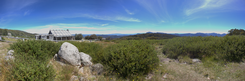
Craig’s Hut is one of the most recognisable photographic locations in Victoria’s High Country. It sits on Clear Hills on the eastern side of Mount Stirling, surrounded by open grassland and snow gums, with extensive views across the surrounding ranges and Upper King River valley.
Despite its appearance, Craig’s Hut is not an original High Country cattleman’s hut. It was originally constructed in 1982 as a film set for The Man from Snowy River. The hut was destroyed during the Great Divide bushfires in 2006 and subsequently reconstructed, reopening to visitors in 2008.
Photographically, the attraction is not simply the building. The combination of the rustic timber hut, split-rail fencing, grass, snow gums and layers of distant mountains creates a distinctly Australian High Country landscape.
The elevated and relatively isolated position makes Craig’s Hut particularly attractive around sunrise and sunset, when low light can define the timber structure, grasses and surrounding mountain ridges. Clear nights can also provide opportunities for photographing the hut beneath the stars.
History
Craig’s Hut was created for the production of The Man from Snowy River. Construction is commonly dated to 1981–82: filming occurred during that period and the film was released in 1982. It was designed to represent the romantic image of a nineteenth-century mountain cattleman’s hut rather than to provide an authentic surviving example of pastoral occupation.
The original film-set structure was not built for long-term survival. After it deteriorated, a replacement was constructed in 1993. That building was destroyed by the Great Divide bushfire on 11 December 2006.
Government funding, contractors and volunteers supported another reconstruction during 2007. The present hut reopened to the public in January 2008. It recreates the familiar film image while using a more durable structure suited to its exposed position and high level of visitation.
Craig’s Hut is therefore historically significant principally for its connection with Australian film, the mythology of the mountain stockman and the development of High Country tourism. It should not be described as an original cattleman’s hut.
The hut stands on Taungurung Country. Its film history sits within a much older cultural landscape and continuing connection between Taungurung people and the mountains, waterways and living Country of the region.
Viewpoints
Any photo that contains both the hut and the mountains it overlooks is good. The time of day changes the landscape colours considerably, as does the time of year, the amount of rain, and of course snow. I personally prefer this location with some snow on it.
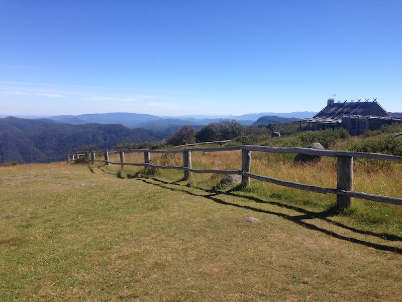
The Classic Hut and Mountain View
The most recognisable compositions place Craig’s Hut prominently in the foreground with the High Country ranges stretching away behind it.
Try several distances rather than relying on a single wide-angle view. Moving farther from the hut and using a moderate telephoto focal length can make the distant mountains considerably more prominent in the composition.
The Split-Rail Fence
The timber fencing around the clearing provides useful foreground structure and leading lines. Look for positions where the fence leads towards the hut rather than cutting horizontally across the photograph.
The fence, hut and distant ridges can work particularly well as a three-layer composition.
Snow Gums and the Hut
The surrounding snow gums provide opportunities to frame the hut and give the photograph a stronger sense of its alpine environment.
Instead of photographing only from the open clearing, move around its perimeter and look for trunks and branches that provide natural framing.
Looking Away from the Hut
Some of the strongest photographs may not contain the hut at all. The elevated position provides broad views towards Mount Cobbler and across the Upper King River valley and surrounding ranges.
Layers of ridges can be particularly effective in mist, haze, side lighting and immediately before or after sunrise.
Details
Allow some time for smaller subjects such as weathered timber, doors and windows, roof textures, fence posts, grasses, wildflowers and snow gums. Frost, ice and snow can provide additional opportunities when conditions permit.
These details help produce a photographic sequence that describes the location rather than simply repeating variations of the classic wide view.
Other Things to Look Out For
What I took - what was in my kit
I took my LowePro Backpack loaded with Canon 5DSR body, Canon 24 mm TS, Canon 16-35mm, Manfrotto 190 Tripod, and of course a range of lens wipes, spare batteries, sunscreen and bug repellant. I basically was only interested in shooting a panorama style photo (Its width 3 times its height). Such photos need high resolution.
Techniques
Photo stitching.
As with many wide scenes (panoramas), you have a choice of a specialised panoramic camera like the Linhof, severely cropping a single image, or stitching several images together. I used multiple Canon 5d images stitched together.
See also the Auspano Photography Techniques page for more general photographic techniques.
Exposure Bracketing
The hut can be substantially darker than a bright sunrise or sunset sky. Exposure bracketing can preserve both highlight and shadow detail without forcing an unnaturally strong graduated-filter effect across the hut and mountain skyline.
Focus Stacking
For compositions containing a very close fence, grass or other foreground feature, focus stacking can help retain detail from the immediate foreground through to the hut and distant mountains.
Panoramas
The extensive mountain views suit stitched panoramas. A normal to short-telephoto lens can often produce a more satisfying panorama than simply using an ultra-wide lens, particularly when the distant ranges are an important part of the photograph.
Long Exposures and Astrophotography
The isolated setting makes Craig’s Hut a potential night-photography subject. The hut can provide a strong foreground for stars and the Milky Way, subject to season, moonlight, cloud and atmospheric conditions.
Keep artificial illumination restrained if other photographers or visitors are present.
Nearby Locations
Craigs Hut is at the eastern edge of the Victorian High Country. From here, there is camping, waterfalls, rivers, river crossings, lookouts, mountain views, alpine huts, horse back riding, shooting, fishing, cross country skiing, etc.... The issue is really what is your interest and how long do you have.
Mount Stirling
The wider Mount Stirling area provides extensive High Country landscapes, snow gums, walking tracks and elevated viewpoints.
Mount Buller
Mount Buller provides alpine landscapes, mountain views and a very different built environment from Craig’s Hut.
Bindaree Falls
Bindaree Falls provides a forest and waterfall subject that contrasts strongly with the open alpine landscape around Craig’s Hut. A short walk through native forest leads to a viewing platform that passes behind the falls.
Howqua Hills
The Howqua area combines river landscapes, forest and High Country history and is worth considering as part of a longer photographic exploration of the district.
Sheepyard Flat
Sheepyard Flat provides river, forest and High Country subjects along the Howqua River.
Mansfield
Mansfield provides heritage and rural photographic subjects as well as being the principal service centre and accommodation base for the district.
Other Things to Look Out For
The Craig’s Hut clearing offers considerably more than the principal building. Look for secondary photographic opportunities including:
- Snow gums with twisted trunks and textured bark.
- Alpine grasses and seasonal wildflowers.
- Frost and ice.
- Fog and low cloud moving through the valleys.
- Mountain ridge silhouettes.
- Backlit grasses.
- Birds and other wildlife.
- Abstract details in weathered timber.
- Stars and the Milky Way.
- Snow-covered landscapes when safely accessible.
Cloud and rapidly changing weather can completely transform the location. A seemingly unpromising overcast visit may produce more atmospheric photographs than a perfectly clear day.
Location
Craigs Hut Clear Hills Track, Mount Buller, Victoria (-37.10832, 146.5328)
Craig’s Hut is on Clear Hills on the eastern side of Mount Stirling in Victoria’s High Country, approximately 50 kilometres by road from Mansfield.
It is reached through the Mount Stirling area via Mount Buller Road, Stirling Road and Circuit Road.
Apple Map – Location and Nearby Photographic Locations
This interactive Apple Map shows Craig’s Hut and worthwhile photographic locations in the surrounding Mount Stirling, Mount Buller and Howqua country. Select a numbered marker or a location in the list below.
Photographic locations
How to Get There
The only way I know to get there is by car, driving up to near Mount Buller (on tarmac), then to Telephone Box Junction and then taking the Circuit Road through to the start of the Clear Hills Track. The Circuit Road is dirt, but I have driven it a couple of times in 2 wheel drive cars. The Clear Hills Track is narrow, steep, rocky and windy. I have seen council 2 wheel drive utes use it though, so it is certainly not impossible for a 2 wheel drive car. Each time I have been there, it has been in a 4WD car, but only using 2WD. The 4WD had improved ground clearance though, and this was handly. If you are not used to bush track driving, I would not recommend this as your first outing for bush 2 wheel driving. Most 4WD drive cars, with their higher clearance, would have no issues with the Clear Hills track. Your passengers might have an issue though, as it is rough and has steep drop offs. This is not far from Melbourne though, and the road / track provides just enough 'bush' driving to provide some excitment without much real risk.
There is another track into Craigs Hut - over Mt Stirling - this is the Monument track which also comes off Circuit Road, but about 200m East of Bindaree Road intersection. I have not tried this. I beleive that it is more of a 4WD drive track than Clear Hills.
From Melbourne
Craig’s Hut is approximately a four-hour journey from central Melbourne, depending on the route, traffic and road conditions.
Travel towards Mansfield and then follow Mount Buller Road through Merrijig towards Mirimbah. After passing the Mount Buller/Mount Stirling entry at Mirimbah, turn onto Stirling Road and continue approximately 8 kilometres on unsealed road to Telephone Box Junction.
From Telephone Box Junction, access towards Craig’s Hut continues through the Mount Stirling/Circuit Road network.
Craig’s Hut itself is directly accessible only by suitable 4WD vehicles. Visitors travelling in 2WD vehicles can park before the 4WD section and continue to the hut using the approximately 3 kilometre return walking track.
Do not rely solely on a vehicle navigation system for the final approach. Seasonal closures and changing road and weather conditions are important considerations in the Mount Stirling area.
Driving from the State Capital
The state capital is used as a consistent reference point. Apple Maps calculates the automobile route to the destination defined in map-config; this may be a public car park or trailhead rather than the hut. The actual route varies with the starting point, traffic, roadworks and closures.
State capital to destination
Calculating the driving route with Apple Maps…
Distance and travel time are Apple Maps estimates and may change with the route and current conditions.
4WD Track & Access
Circuit Road
Craig’s Hut is about 19 kilometres from Telephone Box Junction via Circuit Road. Circuit Road is unsealed and is normally approached from Stirling Road. Surface condition can change markedly after rain, snow, drainage work, fallen trees and heavy traffic.
Clear Hills Track
The official Mount Stirling driving information classifies Clear Hills Track as 4WD-only. It is approximately 2.2 kilometres from Circuit Road to the hut and contains steep sections and drainage humps that require useful ground clearance. Recovery equipment is recommended.
My earlier visits included seeing council utes and other vehicles negotiate the track, and I have driven the approach in a 4WD without needing low range. That personal experience should not be treated as changing the current official classification. Weather, erosion, tyres, clearance, driver experience and oncoming traffic can transform the difficulty.
The track is narrow in places and includes steep edges and limited opportunities to pass. A Chevrolet Silverado 2500 is substantially wider and less manoeuvrable than the vehicles for which many High Country tracks were formed. Check current local advice before taking it beyond Circuit Road, and do not take the 23-foot caravan onto Clear Hills Track.
Walking alternative
Visitors not using a suitable 4WD can park at the Circuit Road Picnic Area, approximately one kilometre before the Clear Hills Track turn-off. The signed walking route to Craig’s Hut is about 1.6 kilometres each way, generally described as approximately 3 kilometres return.
In winter the road network is seasonally closed. Reaching the hut then becomes a snow journey suited to people with the appropriate cross-country skiing, navigation and alpine-weather skills rather than a conventional drive or short walk.
Current Access / Conditions
Information checked 21 September 2026.
As at this date, the Circuit Road gate at Telephone Box Junction is closed for the seasonal winter period. Mount Stirling advises that reopening is scheduled for 29 October 2026, subject to weather, road condition and operational assessment.
Seasonal road closures generally operate from after the King’s Birthday weekend until immediately before the Melbourne Cup weekend, but opening may be delayed when conditions are unsafe.
Outside seasonal closure, official information describes direct hut access as suitable for 4WD vehicles. The alternative is the approximately 3 kilometre return walking track from Circuit Road Picnic Area.
Alpine weather, fire, flood, fallen trees, maintenance and track damage can change access at short notice. Check Mount Stirling’s road and trail information, Parks Victoria seasonal closures, VicEmergency and the forecast immediately before departure.
Best Time to Visit
The roads to the hut are closed when snow is expected (June to November). Craig's Hut is on the side of Mount Stirling, which is a cross country skiing location (in winter only). During summer though, while the hut is easily accessable, the grasses have often died off and the trees begin to suffer. Spring and Autumn are therefore the best times of year. Late Autumn is my favourite, as at this time of year you can still get a dump of snow to have around the hut, but they have yet to close the roads.
Sunset (or Sunrise) is my favourite time to photograph the Hut. It gives indirect light to the hut, but you can also get interesting skies.
Sunrise
Sunrise is potentially the most rewarding period for landscape photography. Arriving before first light allows time to establish compositions before colour begins to develop.
Low sunlight can illuminate the hut and grasses while atmospheric haze or mist separates the distant mountain ridges.
Morning
Early morning remains productive while shadows are long and the light retains some warmth. Frost and dew can provide additional foreground interest during colder months.
Middle of the Day
Midday light is generally less flattering for the classic broad landscape, but it can work for hut details, documentary photographs and compositions using clouds and strong graphic shapes.
It is also a useful time to scout compositions for later light.
Late Afternoon and Sunset
Late afternoon can produce warm light on the hut, grass and snow gums, followed by increasingly layered mountain silhouettes towards sunset.
Remain after the sun disappears. The softer colour and reduced contrast during blue hour can sometimes be more successful than the sunset itself.
Night
Craig’s Hut can provide an excellent foreground for astrophotography. Plan Milky Way photographs in advance so that its seasonal position works with the hut and your intended composition.
Accessibility
Accessibility depends considerably on how Craig’s Hut is approached.
Direct vehicle access to the hut is restricted to suitable 4WD vehicles when the relevant roads and tracks are open.
Visitors approaching from the Circuit Road Picnic Area should expect an unsealed walking track through natural High Country terrain. The Craig’s Hut walk is approximately 3 kilometres return.
Once you get to the car park near the hut, there are a couple of steps, but the rest is wide open well maintained paths. The hut itself is on a 'rise' (i.e. a slight hill) - but it is basically wide open land that anyone should be able to move around. There are also picnic tables and toilets near the car park. As mentioned, this is a place to take families, visitors and children and to have picnics. I am not sure about BBQ facilities. I have my own, but I dont recall seeing any. There is a camp site about 100m away down the hill.
The open ground immediately around the hut is natural grass and uneven terrain rather than a paved photographic platform.
Photographers with limited mobility should check current access conditions before travelling, particularly if relying on close vehicle access.
Camping & Overnight Use
Camping is available in the vicinity of Craig’s Hut in the designated camping area below the main hut clearing. Use an established site, keep vehicles on formed access routes and avoid expanding the disturbed area into alpine vegetation.
Craig’s Hut is not bookable accommodation and should not be used for a planned overnight stay. Victorian High Country huts are retained as heritage places and emergency refuge. Bring a tent and a fully self-contained sleeping system even when a hut is nearby.
Mount Stirling advises that a per-night camping fee applies year-round from 1 June 2026. Confirm the current charge and payment method before arrival, including any separate winter resort-entry requirements.
Toilets and picnic tables are provided near the hut/camping area. Do not assume that drinking water will be available. Carry sufficient water; if natural or tank water is used, treat it before drinking.
Fire restrictions vary with season and conditions. Use only a lawful fireplace where fires are expressly permitted, comply with Total Fire Ban and fire-danger restrictions, bring your own appropriate fuel where required, and leave no rubbish or food scraps.
Dogs are listed as permitted at Craig’s Hut, but they must remain under effective control and must not disturb wildlife, horses, campers or other visitors. Confirm current rules before travelling because adjoining protected areas can have different restrictions.
Where to Stay
There is a quite large camp ground near the hut and toilets are provided between the campsite and the hut.
There are also many other campgrounds within a few miles of the hut. This is a pretty popular camping and fishing area.
The nearest town of any size is Mansfield. This town has several accomodation options, and I have stayed at the Caravan Park there. (I slept in my tent). I can recommend the pubs there for dinner, and the bakery for baked goods and breakfast / lunch.
Mansfield region accomodation search
Merrijig
Merrijig is a useful photographic base because it places the photographer closer to Mount Stirling than Mansfield while retaining convenient road access.
Merrijig Motor Inn
1915 Mount Buller Road
Merrijig VIC 3723
Telephone: (03) 5777 5702
Website: merrijigmotorinn.com.au
This is a practical base when an early departure for Craig’s Hut is more important than being close to Mansfield’s wider range of shops and services.
Mansfield
Mansfield is the principal service centre for the area and provides a much wider range of accommodation, fuel, food and supplies.
High Country Holiday Park
1 Ultimo Street
Mansfield VIC 3722
Telephone: (03) 5775 2705
Website: highcountryholidaypark.com.au
Mansfield also has numerous motels, apartments and other accommodation options, making it the most flexible base for a multi-day photographic visit to the region.
Photography Recommendations
Wide-Angle Lens
A wide-angle zoom in approximately the 16–35mm range is useful for environmental photographs that place the hut within the broad clearing and mountain landscape.
Avoid automatically using the widest focal length. Excessive foreground can make the hut and distant ranges appear disappointingly small.
Standard Zoom
A 24–70mm-equivalent zoom is likely to be one of the most useful lenses at Craig’s Hut. It provides enough width for the landscape while allowing tighter compositions of the hut and its surroundings.
Telephoto Zoom
A 70–200mm-equivalent lens is strongly recommended. Telephoto compression can make the layers of distant mountain ridges much more prominent and can produce photographs quite different from the familiar wide-angle Craig’s Hut views.
It is also useful for isolating details of the hut, snow gums and distant landscapes.
Tripod
A tripod is particularly useful around sunrise, sunset and blue hour and for astrophotography, panoramas, exposure bracketing and focus stacking.
Polarising Filter
A polariser may help manage reflections from foliage and strengthen colour under suitable conditions. Use it cautiously on very wide compositions containing large areas of blue sky because the polarising effect can become uneven.
Graduated Neutral-Density Filters
Graduated filters can be useful where the skyline is reasonably clean. Exposure bracketing may be preferable where the hut, trees and mountain ridges project significantly into the sky.
Drone Photography
The elevated landscape may appear attractive from the air, but drone operation should not be assumed to be permitted simply because the area is remote. Check current CASA requirements and the rules applying to the particular land-management area before flying. Fire operations, emergency activity and temporary restrictions may also affect drone use.
Field composition sequence
Work the hut as both a subject and a foreground: begin with an environmental frame showing the surrounding ridges, then move closer to isolate timber detail and the roofline. Watch the horizon where it meets the building and leave room for the mountain setting.
Suggested Photographic Sequence
Afternoon: Arrive with enough daylight to walk around the clearing and identify foregrounds, fence lines and mountain backgrounds.
Late afternoon: Photograph details, snow gums and tighter compositions as the light becomes more directional.
Golden hour: Concentrate on the principal hut-and-mountain compositions, but continue changing focal length and position rather than remaining at one viewpoint.
Sunset: Work both the hut and the surrounding mountain landscape. Watch the opposite side of the sky as well as the direction of sunset.
Blue hour: Photograph the hut against the softer post-sunset sky and mountain silhouettes.
Night: If conditions and access arrangements allow, photograph stars or the Milky Way with the hut as foreground.
Pre-dawn: Return to the preferred viewpoint before the sky begins to brighten.
Sunrise: Concentrate initially on the compositions identified during the previous afternoon, then respond to changing light, mist and cloud.
Early morning: Finish with details, frost or dew if present, snow gums and telephoto mountain landscapes.
How Long Should a Photographer Stay?
A casual visitor can see and photograph Craig’s Hut in approximately one to two hours, particularly in good daylight.
For a photographer, allow at least three to four hours so there is time to explore the clearing, change viewpoints and wait for changing light.
For a comprehensive visit, the ideal approach is to photograph late afternoon through sunset and blue hour, followed by sunrise the next morning.
Staying in Merrijig or Mansfield for at least one night greatly improves the opportunity to work the location in good light. Two nights provide considerably more flexibility if cloud, fog or poor weather interferes with the first session.
My Priority Photographs
- Classic Craig’s Hut and High Country mountain landscape.
- Hut with the split-rail fence used as a leading line.
- Telephoto hut-and-mountain composition compressing the distant ridges.
- Hut framed by snow gums.
- Wide environmental photograph showing the full clearing.
- Sunrise light across the hut and grass.
- Sunset or blue-hour photograph.
- Layered mountain ridges without the hut.
- Weathered timber and architectural details.
- Snow-gum details and bark.
- Frost, mist, snow or dramatic weather if present.
- Night photograph of Craig’s Hut beneath the stars or Milky Way.
Hut Information
| Hut name | Craig’s Hut |
|---|---|
| Location / area | Clear Hills, north-east of Mount Stirling, Mansfield State Forest, Victoria |
| Traditional Country | Taungurung Country |
| Original construction | Constructed during 1981–82 for The Man from Snowy River; frequently described by the film’s 1982 release year |
| Builder / associated people | Created by the film production as the home of the fictional Craig family; later reconstructions involved government, contractors and community volunteers |
| Original purpose | Film set representing a nineteenth-century High Country cattleman’s hut |
| Construction | Rustic timber hut designed to reproduce the visual character of a mountain stockman’s dwelling |
| Current status | Public reconstruction; not the original film-set structure and not a bookable accommodation hut |
| Destruction / rebuild history | Original set deteriorated; replacement built in 1993; destroyed by the Great Divide fire on 11 December 2006; reconstructed during 2007 and reopened in January 2008 |
| Historical significance | Australian film history, popular mythology of the mountain stockman, regional identity and High Country tourism |
| Vehicle access | Circuit Road followed by 2.2 km Clear Hills Track; direct access officially classified as 4WD-only |
| 4WD difficulty | Short but narrow and steep in places, with drainage humps; suitable clearance and recovery equipment recommended |
| Final walk | Approximately 3 km return from Circuit Road Picnic Area; about 1.6 km each way depending on mapped endpoint |
| Seasonal closures | Winter closure generally from after the King’s Birthday weekend until immediately before Melbourne Cup weekend; dates may change with conditions |
| Parking | Circuit Road Picnic Area for the walking route; limited parking near the hut for vehicles that lawfully negotiate Clear Hills Track |
| Camping | Designated camping available near the hut; per-night Mount Stirling camping fee applies year-round from 1 June 2026 |
| Sleeping in hut | Not permitted as planned accommodation; hut is a heritage structure and emergency refuge |
| Facilities | Toilets and picnic tables near the hut/camping area; services are basic |
| Water | No reliable treated drinking water; carry adequate water and treat any natural or tank supply |
| Dogs | Listed as allowed at Craig’s Hut; keep under effective control and confirm current rules for the intended route |
| Managed by | Victorian Government land management in Mansfield State Forest, with access through the Mount Stirling road and visitor network |
| Hut coordinates | -37.10827, 146.53280 |
| Information checked | 21 September 2026 |
Photo Subjects
Explore related Auspano photography guides by subject.
Photographer Comments & Updates
Have you photographed this location? Share your photographs, viewpoints, photography tips or recent access updates, or ask a question about visiting. When uploading your own photographs, please include your name and the date each photograph was taken. Date any access or track-condition observations; visitor reports may become outdated, so check official information before travelling.