About the Central Yarra River
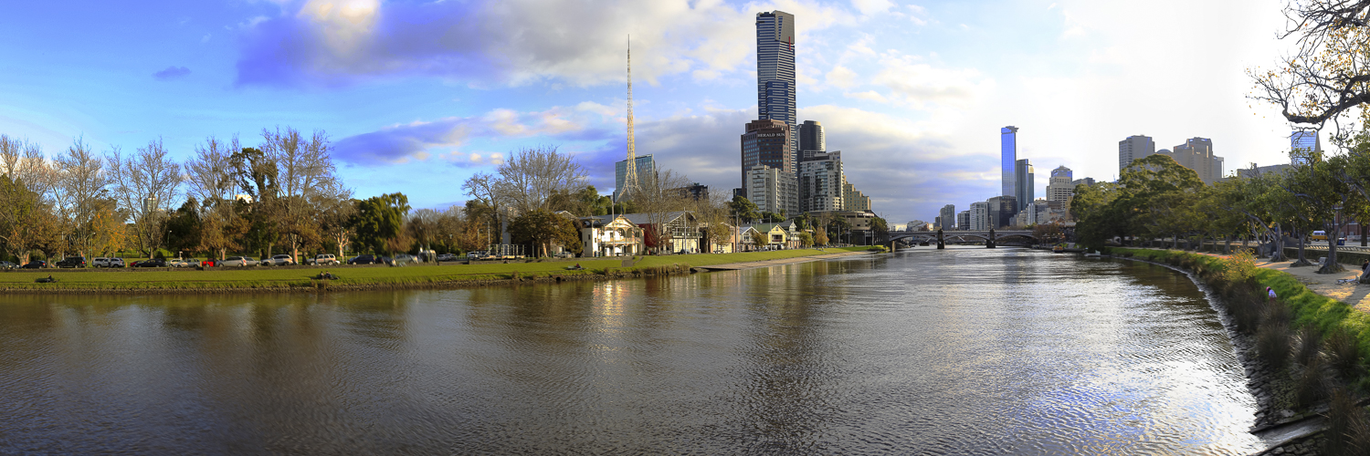
The Yarra River, known to Traditional Owners as the Birrarung, runs for about 242 kilometres from the Yarra Ranges to Port Phillip. This page concentrates on the compact central-city reach between Birrarung Marr, Princes Bridge, Southbank and the Docklands bridges—the section most useful as a single photographic walk.
Here the river is less a wilderness landscape than Melbourne’s reflective foreground. Historic railway viaducts, modern towers, bridges, rowing craft, ferries, public art and pedestrians change character from sunrise to blue hour. The strongest photographs usually combine water with a recognisable city element rather than treating the river alone as the subject.
Begin with the Melbourne overview guide, then use the linked detailed pages for nearby locations.
Viewpoints
1. Princes Bridge
The bridge provides broad views both east and west. Looking west gives the river, railway lines, Southbank and towers; looking east includes Birrarung Marr, rowing activity and parkland. Keep clear of cyclists and commuters.
2. Southbank Promenade
From the south bank, use the river as foreground for Flinders Street Station, St Paul’s Cathedral and the northern skyline. Low positions emphasise reflections; higher bridge positions simplify them.
3. Evan Walker Bridge and Sandridge Bridge
These crossings create strong curves, repeating structure and elevated views. Sandridge Bridge’s sculptural elements and former railway alignment add historical context.
4. Seafarers Bridge
The white cable-supported structure is a graphic subject in its own right and also provides views towards the convention precinct, wharves and western skyline.
5. Webb Bridge and Docklands
Webb Bridge’s woven form, water reflections and apartment backdrop work especially well at blue hour. Walk around rather than relying on one symmetrical view.
6. Birrarung Marr
Parkland on the north bank offers softer foregrounds, river mist, event activity and views towards the sporting precinct. It also connects naturally to Federation Square.
Other Things to Look Out For
How I Photograph the Yarra River
What I take
A 16–35 mm lens covers bridges, skyline and close architectural foregrounds; a 24–70 mm lens is the main walking lens; and a short telephoto isolates towers, rowers, ferries and compressed bridge layers. A travel tripod is valuable at sunrise, blue hour and night but must never obstruct the promenade.
Techniques
Use shutter speed deliberately. A short exposure preserves rowers and ripples; several seconds smooths water and stretches reflections. Bracket skyline scenes around sunrise and blue hour, and protect bright building signs. A polariser can reduce glare but may also remove the reflections that make the scene work.
Other things to look out for
Look for rowers, ferries, birds, mooring lines, bridge shadows, trains beside the river, public art, fog, storm light and reflections after rain. A tram or train in the background can make the image unmistakably Melbourne.
Nearby Locations
Flinders Street Station
The clocks, dome, platforms and river-facing façade are immediate companions to a Princes Bridge session.
Hosier Lane
Changing street art is only a short walk from Federation Square and can fill the flat midday period.
AC/DC Lane and Yarra River — Central Melbourne
Connected music and mural locations east of Russell Street, useful before returning to the river for evening light.
Federation Square and Birrarung Marr
Modern architecture, events, parkland and cultural interpretation sit directly beside the river.
Docklands and Victoria Harbour
Contemporary bridges, promenades, boats and western sunset light extend the river walk.
Melbourne photographic overview
Use the overview page to connect the river with the city’s detailed architecture, garden and street-art guides.
Location
Central Yarra River / Birrarung
Primary reference point: Princes Bridge
Melbourne, Victoria 3000
Central coordinates: approximately -37.81910, 144.96830.
This page covers the city reach from Birrarung Marr to Webb Bridge. The map markers represent public photographic positions along bridges and promenades, not a single destination.
Apple Map – Location and Nearby Photographic Locations
The Apple Map follows the most productive central-city section of the Birrarung from Princes Bridge towards Docklands, then identifies nearby city subjects. Select a marker for coordinates; conditions, events and construction may alter the exact usable position.
Photographic locations
How to Get There
The most convenient starting point is Flinders Street Station. Exit towards Federation Square or Princes Bridge and join either river bank. Southern Cross Station is useful when walking in the opposite direction from Docklands.
The central-city Free Tram Zone reaches close to much of this route, but walking is the best photographic method. Do not drive between viewpoints; CBD and Southbank parking is expensive and event traffic can be heavy.
Driving from the State Capital
The state capital is used as a consistent reference point. Apple Maps calculates the automobile route to this location; your actual route may vary with your starting point, traffic, roadworks and temporary closures.
State capital to destination
Calculating the driving route with Apple Maps…
Distance and travel time are Apple Maps estimates and may change with the route and current conditions.
Current Access / Conditions
Information checked September 2026. The central promenades and bridges remain public urban spaces, but major events, riverside construction, maintenance, flooding and temporary closures can affect access. Check City of Melbourne and event notices before a time-critical visit.
The river has working vessels, slippery edges and fast bicycle traffic. Remain behind barriers, keep tripod legs out of through-routes and never step onto railway, wharf or service areas for a composition.
Best Time to Visit
Sunrise
Quiet promenades, softer eastern light and occasional mist give the best chance of uncluttered architectural reflections.
Golden hour
Low light catches towers and bridge structure, although the most useful bank depends on season and direction.
Blue hour and night
This is often the strongest period: building lights balance with the sky and reflections become longer and more colourful.
After rain
Wet paving doubles city lights and adds foreground texture. Protect equipment and avoid slick river-edge surfaces.
Winter mornings
Cool air can provide mist, subdued colour and lower sun angles, with fewer early pedestrians.
Accessibility
Much of the central riverfront has step-free promenades, ramps and accessible public transport nearby. Princes Bridge, Federation Square, Southbank and the major pedestrian bridges can generally be reached without stairs.
Gradients, crowding, temporary event barriers, cobbles and shared bicycle paths vary. Plan a shorter section if mobility is limited and confirm lift availability at railway stations before travel.
Where to Stay
Southbank provides the most direct access to river viewpoints and makes dawn or night photography easy. The CBD around Flinders Street and Federation Square is equally practical, while Docklands suits Webb Bridge and western harbour subjects. See the Melbourne overview for wider location planning.
Photography Recommendations
- Plan a direction of travel around the light: east-to-west for an afternoon-to-blue-hour walk works well.
- Make both bridge-top panoramas and low river-level reflection studies.
- Use a short exposure for boats and rowers before trying long water exposures.
- Include a recognisable Melbourne element such as the station, cathedral, train or bridge.
- Level the camera for skyline work and leave room for perspective correction.
- Keep tripods compact and clear of commuters, cyclists and venue entrances.
- Return in different weather; mist, storms and wet paving change the river completely.
Field composition sequence
Work along the river to compare bridge-led views, skyline reflections and details on the banks. Include one wide scene-setting frame and a tighter image that uses the water as a graphic foreground.
Suggested Photographic Sequence
- Begin at Birrarung Marr before sunrise for mist, park and eastern river views.
- Move to Princes Bridge for broad views in both directions.
- Descend to Southbank for Flinders Street Station and cathedral reflections.
- Continue west across Evan Walker and Sandridge bridges, photographing both banks.
- Use late light around Seafarers Bridge and the wharf precinct.
- Finish at Webb Bridge for blue hour, then photograph the illuminated route back if energy permits.
How Long Should a Photographer Stay?
Allow three to five hours for a deliberate Princes Bridge-to-Webb Bridge walk, including both banks and tripod work. A shorter Princes Bridge, Southbank and Birrarung Marr circuit needs about 90 minutes to two hours. Two sessions—sunrise and blue hour—produce a much stronger gallery than one midday visit.
My Priority Photographs
- Flinders Street Station and St Paul’s Cathedral reflected from Southbank.
- A wide east-or-west panorama from Princes Bridge.
- A train beside the river to establish Melbourne context.
- Sandridge or Evan Walker Bridge used as a strong leading line.
- Seafarers Bridge as a clean architectural composition.
- Webb Bridge at blue hour with reflections.
- Rowers, ferries or birds against the city.
- Wet-pavement city lights or early river mist.
Photo Subjects
Explore related Auspano photography guides by subject.
Photographer Comments & Updates
Have you photographed this location? Share your photographs, viewpoints, photography tips or recent access updates, or ask a question about visiting. When uploading your own photographs, please include your name and the date each photograph was taken. Date any access or track-condition observations; visitor reports may become outdated, so check official information before travelling.