Photographing Devils Gullett
About Devils Gullet
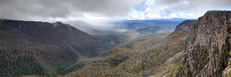
Located in the Central Plateau of Tasmania, Devils Gullet is one of many rugged mountain / valley / cliffs in this area. The gorge is some 220 metres deep, and the tops are covered in Alpine Forests that can get snow in winter. This is a short drive away from Walls of Jurusalem and Cradle Mountain.
Viewpoints
There are infinite choices here, but in two categories:
- There is a lookout (where the top photo was taken). This should be your first stop. It not only lets you get a good view of the gorge, but it lets you spot where you want to take other photos from. The viewpoint is quite good.
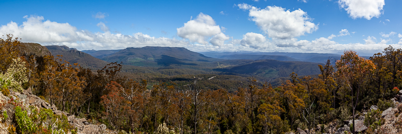
- The second option is at the side of one of the roads besides the gorge, or from above using a drone. This is how the second photo was taken. These provide a more unique photo, but they are harder to find. You will need to do some planning or bush bashing to get to one of these spots.
Other Things to Look Out For
How I photographed Devils Gullet
What I took - what was in my kit
I took my LowePro Backpack loaded with Canon 5DSR body, Canon 16-35mm zoom, Manfrotto 190 Tripod, and of course a range of lens wipes, spare batteries, sunscreen and bug repellant. I tended to shoot 16mm here, as the vista is huge, and it is impossible to get it all into a 35mm or 50m shot.
Techniques
This area can get snow, but we were there on a warm sunny day. Contrast was my biggest concern and composure second. To reduce contrast I shot HDR, and particually tried to wait until the sun was behind one of the clouds. To try and 'get it all in', I shot a panograph by stitching 5 16mm shots together.
Nearby Locations
Nearby photographic locations
Location
Devils Gullet, Central Highlands, Tasmania
Approximate coordinates: -41.69640, 146.34260
Markers identify photographic objectives rather than guaranteed parking spaces or open access.
Apple Map – Location and Nearby Photographic Locations
This Apple Map shows the principal subject and nearby photographic locations. Verify signs, road status and track conditions before relying on a marker for access.
Photographic locations
How to Get There
From Hobart
Use the mapped Apple Maps route as a planning reference, then confirm road type, closures, fuel availability and final access with the relevant park or road authority. Allow extra time for photographic stops and changing conditions.
Driving from the State Capital
The state capital is used as a consistent reference point. Apple Maps calculates the automobile route to this location; your actual route may vary with your starting point, traffic, roadworks and temporary closures.
State capital to destination
Calculating the driving route with Apple Maps…
Distance and travel time are Apple Maps estimates and may change with the route and current conditions.
Current Access / Conditions
Conditions checked: 22 September 2026.
Check Tasmania Parks alerts and Tasmania Police road information before travel. Alpine weather, ice, snow, fire and maintenance can alter access rapidly.
A valid parks pass is required where the site is within a national park. At Cradle Mountain, private vehicle access beyond the visitor centre is restricted during shuttle operating hours and parking is limited.
Best Time to Visit
Tasmania is considerably colder than the mainland. It nicer to visit in summer due to the weather, but it more photogenic in the winter when snow can be found on many of the alpine peaks.
Accessibility
Access varies between surfaced visitor areas and natural tracks. Expect uneven, wet or loose surfaces and carry water, first aid, offline mapping and clothing for rapid weather changes.
Where to Stay
We stayed at Mole Creek, which is only some 20km away. It has nice hotels and campgrounds / caravan parks. Apart from this, Deloraine is a bigger town (40km away), and Cradle Mountain is a brilliant spot - but probably 60km vy road (and less than 20km as the crow flies).
Photography Recommendations
Photography recommendations
- Begin with a clear environmental composition before concentrating on details.
- Use a tripod only where it will not obstruct a path, platform, jetty or working area.
- Bracket high-contrast scenes and protect important highlights.
- Use a telephoto to simplify distant layers and avoid approaching wildlife or fragile features.
- Revisit the principal viewpoint as weather, tide or light changes.
Suggested photographic sequence
- Arrive early enough to inspect access and choose safe viewpoints.
- Make the broad establishing photographs while the location is quiet.
- Work through secondary markers and detail subjects.
- Return to the main composition for golden hour or softer late light.
- Finish with blue hour only where the route back is straightforward and safe.
How long should a photographer stay?
Half day is a practical minimum. Add time when weather, water flow, tides or remote-road conditions are central to the planned photographs.
My priority photographs
- A defining environmental view of Devils Gullet
- A tighter composition showing the location’s characteristic texture or structure
- A photograph using a person, vehicle, building or vegetation to communicate scale
- A low-light or weather-driven image that differs from the standard visitor view
Suggested Photographic Sequence
Work through the location in an order that makes the best use of changing light and conditions.
How Long Should a Photographer Stay?
Allow enough time to photograph the location in more than one light or weather condition where practical.
My Priority Photographs
Use this section for the practical photographic shot list for the location.
Photo Subjects
Explore related Auspano photography guides by subject.
Photographer Comments & Updates
Have you photographed this location? Share your photographs, viewpoints, photography tips or recent access updates, or ask a question about visiting. When uploading your own photographs, please include your name and the date each photograph was taken. Date any access or track-condition observations; visitor reports may become outdated, so check official information before travelling.