Photographing Patchewollock Silo
About Patchewollock Silo
Patchewollock is a small Mallee town in north-western Victoria, approximately 420 kilometres by road from Melbourne. Surrounded by broad-acre farmland, mallee scrub and some of Victoria's most expansive skies, it offers photographers a very different landscape from the mountains and coastline found elsewhere in the state.
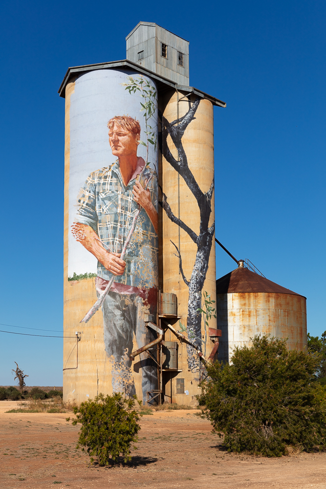
The town is best known photographically for the Patchewollock Silo Art, one of the major works on Victoria's Silo Art Trail. Brisbane artist Fintan Magee transformed the GrainCorp silos in 2016 with a huge portrait of local sheep and grain farmer Nick "Noodle" Hulland.
The mural has become one of the defining images of the Wimmera Mallee. The tall, narrow figure works particularly well with the proportions of the silos and, photographically, can be framed against either blue Mallee skies, storm clouds or the warm light of late afternoon.
Patchewollock is also an excellent base for exploring the northern part of Wyperfeld National Park. From town it is possible to reach Pine Plains, Snowdrift, Casuarina and other areas of the park, allowing photographers to combine silo art with sand dunes, mallee woodland, grasslands, wildlife and extraordinary night skies.
Unlike a conventional tourist destination, part of Patchewollock's appeal lies in the spaces between the recognised attractions. Long straight roads, isolated trees, grain fields, old sheds, abandoned structures, farm machinery and enormous horizons are all worthwhile photographic subjects.
More information: Visit Victoria - Patchewollock Silo Art
Viewpoints
-
The Patchewollock silos are the town's signature photographic subject and should be considered the essential first stop.
Painted by Fintan Magee in 2016, the mural depicts local farmer Nick "Noodle" Hulland and represents the hardworking agricultural character of the Mallee.
Best for: silo art, rural landscapes, environmental portraits, architecture, sunset and night photography.
Best light: late afternoon is particularly attractive, when warm light can bring out the texture of the concrete silos. Overcast skies can also work very well because they reduce contrast across the mural.
Photography tip: do not restrict yourself to a tight photograph of the mural. Step farther back and include surrounding railway infrastructure, roads, farm country or a large expanse of sky to place the artwork within its Mallee environment.
A 24-70mm lens is probably the most useful choice, while a 70-200mm is excellent for isolating details of the portrait.
GPS: approximately -35.38444, 142.18814
Address: Baring Road / Federation Street, Patchewollock VIC 3491
Australian Silo Art Trail - Patchewollock
The silo painting has been designed to be viewed from the town centre, which is to the east-north-east of the silo. Thankfully, there is a large car park on the northern side of the silo, and a park to the east, so it is easy to both park and walk around the north to eastern sides of the silo. The only trouble with the north-eastern viewpoint from the car park is that the viewpoint is fairly low, so most photos will result in considerable 'tombstoning' where the silo appears to be falling backwards. This can be correctly via a tilt-shift lens, a drone, or partially via post processing software (aka Photoshop). Moving further away from the silo and using a longer focal length lens would clearly have reduced the tombstoning, but it would also have placed me behind some trees lining the side of the road / in the park. There are plenty of shrubs / trees around the area, and my final composition included some shrubs in the foreground to provide 'foreground interest'.
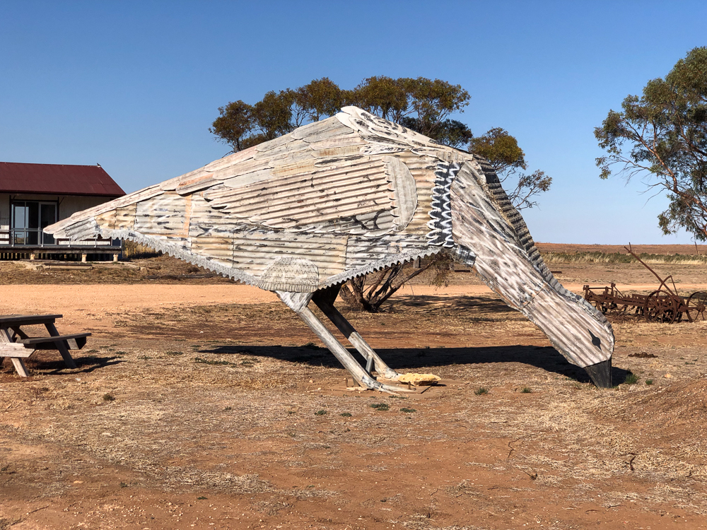
It is worth taking a walk through the park to the North east of the silo. This park contains large Mallee Fowl statues - both a male and a female, and their nest.
-
Patchewollock Hotel and Federation Street
The small centre of Patchewollock provides opportunities for documenting a traditional Mallee settlement rather than simply photographing the silo mural.
Subjects include the Patchewollock Hotel, old commercial buildings, roadside details, the former railway environment, weathered sheds and the broad streets typical of small agricultural towns.
Best for: rural documentary photography, historic architecture, street scenes and environmental details.
Best light: early morning or the final hour before sunset.
A 35mm or 50mm lens is particularly useful if you want a natural documentary appearance.
-
Patchewollock Mallee Fowl Artwork
Around the central Patchewollock precinct, look for the large Mallee Fowl artwork and other pieces of local public art. They provide useful secondary subjects when photographing the town and help tell the story of the surrounding Mallee environment.
Best for: public art, travel photography and quirky roadside subjects.
-
Patchewollock Farming Country
Some of the strongest landscape photographs around Patchewollock can be made simply by exploring the sealed roads surrounding the town.
Look for isolated trees, long straight roads disappearing towards the horizon, harvested fields, grain crops, fences, old sheds, machinery and windmills.
Best for: minimalist landscapes, rural Australia, thunderstorms, sunsets and road photographs.
Best light: approximately one hour after sunrise and the final hour before sunset.
A 70-200mm lens is especially useful here because it allows you to compress distant trees, farm buildings and layers of agricultural land.
Always remain on public roads and road reserves unless you have permission to enter private property.
-
Pine Plains lies north-west of Patchewollock and provides one of the most convenient gateways into the northern section of Wyperfeld National Park.
The area combines mallee woodland, open country, native vegetation, old station landscapes and access towards Snowdrift.
Best for: mallee landscapes, wildlife, sunrise, sunset, bird photography and astrophotography.
Pine Plains Lodge is approximately a 15 to 20 minute drive from Patchewollock, predominantly along a good gravel road.
-
Snowdrift - Wyperfeld National Park
Snowdrift is one of the outstanding photographic locations in northern Wyperfeld National Park.
A large pale sand dune rises dramatically from the surrounding Mallee landscape, providing elevated views across an otherwise remarkably flat region.
Best for: sand dunes, patterns, sunsets, silhouettes, panoramic landscapes and night photography.
Best light: very late afternoon and sunset. Low-angle light produces shadows across the dune and emphasises the texture of the sand.
Photography tip: a wide-angle lens works well for sweeping dune landscapes, but a 70-200mm can be even more effective for isolating ridges, shadows and individual trees.
Avoid unnecessarily disturbing vegetation growing on or around the dunes.
-
Casuarina Area - Wyperfeld National Park
The Casuarina area provides another accessible introduction to northern Wyperfeld and includes woodland, dry watercourses, open Mallee landscapes and walking opportunities.
Best for: native vegetation, kangaroos, emus, birds, intimate landscapes and sunset.
Carry a 100-500mm or similar telephoto if wildlife photography is important.
-
Patchewollock Night Sky
One of Patchewollock's greatest photographic assets appears after sunset.
The very low level of artificial light in the surrounding countryside makes this an excellent district for astrophotography.
Potential foregrounds include the silos, isolated Mallee trees, old farm structures, windmills and the sand dunes of Wyperfeld.
Best for: Milky Way photography, star trails and night landscapes.
Choose a moonless night for maximum star visibility, or use a small amount of moonlight when you want the landscape itself to remain visible.
Google Map - Patchewollock Photographic Viewpoints
The map below combines the main Patchewollock photography locations with the northern Wyperfeld locations that are most naturally visited from the town.
How I photographed Patchewollock Silo
What I took - what was in my kit
I took my LowePro Backpack loaded with Canon 5DSR body, Canon16-35mm zoom, Manfrotto 190 Tripod, and of course a range of lens wipes, spare batteries, sunscreen and bug repellant. I tended to shoot 28-55mm
Techniques
TBD
Other things to look out for
Patchewollock is a good base for exploring the wider Wimmera Mallee. Several worthwhile photographic destinations are within approximately an hour's drive. If a photographer has traveled 4 hours from Melbourne to the 'Western District', then it would be a shame not to check out: Lascelles Silo, Albacutya Silo, Lake Tyrell, Lake Boga Silo, etc.
-
Wyperfeld National Park
Wyperfeld is one of Victoria's great Mallee national parks and should be considered the most important natural photographic destination close to Patchewollock.
The landscape includes mallee woodland, heathland, sand dunes, dry lake systems, woodlands and open plains.
Kangaroos, emus and a wide variety of birds may be encountered, particularly during the cooler parts of the day.
Best for: wildlife, dunes, woodland, wildflowers, panoramas, sunset and astrophotography.
Parks Victoria advises visitors to bring their own drinking water and to prepare carefully for the remote semi-arid environment.
-
Lake Lascelles, Hopetoun - approximately 35 to 40 minutes
Lake Lascelles provides a very different photographic environment from the dry Mallee country surrounding Patchewollock.
Calm water, reeds, shoreline vegetation and open skies can provide excellent reflections at sunrise and sunset.
Best for: reflections, sunrise, sunset, birdlife, astrophotography and tranquil landscapes.
This is also a useful accommodation alternative, with cabins, powered caravan sites and unpowered camping available beside the lake.
-
Lascelles Silo Art - approximately 40 minutes
Lascelles is another important stop on the regional Silo Art Trail and can readily be combined with Patchewollock in a single photography trip.
The surrounding flat farmland and small-town setting provide opportunities to photograph the artwork in its broader agricultural context.
Best for: silo art, rural architecture and Mallee landscapes.
-
Woomelang offers a particularly enjoyable variation on the Silo Art Trail. Rather than one enormous grain silo mural, a collection of small silos has been painted with images of threatened Australian wildlife.
Best for: wildlife-themed public art, details and travel photography.
-
Albacutya provides another major work of silo art within the broader Wimmera Mallee photography circuit.
The isolated rural position means the surrounding agricultural landscape can be incorporated into photographs far more easily than at many urban murals.
Best for: silo art, rural landscapes and road-trip photography.
-
Lake Albacutya is a large internationally recognised Ramsar wetland situated north of Lake Hindmarsh.
The lake is naturally intermittent and may remain dry for extended periods, so its photographic character varies dramatically according to rainfall and water conditions.
Even when dry, the broad lake bed, shoreline trees and enormous horizon can produce striking minimalist landscapes.
Best for: wetlands when water is present, dry lake landscapes, birds, isolated trees and sunsets.
-
Rainbow
Rainbow is a useful southern gateway to Wyperfeld National Park and another interesting small Mallee town for photographers.
Subjects include heritage buildings, rural streetscapes and the Rainbow Silo Art installation.
Google Map - Patchewollock and Nearby Photographic Locations
This map shows Patchewollock in relation to Wyperfeld National Park, Lake Lascelles, Lascelles, Woomelang, Albacutya and Rainbow.
Location
Patchewollock, Vic 3491
///lament.vortex.precluded (-35.384388866805594, 142.18691541255524)
Patchewollock Silo Art
Address:
Patchewollock Silo Art
Baring Road / Federation Street
Patchewollock VIC 3491
Australia
GPS:
-35.38444, 142.18814
Google Maps: Patchewollock Silo Art
Techniques used
- Techniques
- Normal Style
- Long Exposures
- Nuetral Density Filters
- High Dynamic Range
- Focus Stacking
- Remove People
- Photo Stitching
- Movements
- Tombstoning
- ISO
- Shutter Speed
- Depth of Field
- Diffraction
- Moving the eye around the picture
- Golden and Blue Hour
- Infra-Red Photography
- Raw vs JPG (JPEG)
- Camera Modes
- Expose to the Right
- Sharpness
- Fore, Middle, Far
- Rule of Thirds
Kit used
How to get there
Driving from Melbourne
Patchewollock is approximately 420 kilometres by road from Melbourne and normally requires around 4¾ to 5 hours of driving, excluding substantial stops.
A practical route is:
Melbourne → Ballarat → Avoca → St Arnaud → Donald → Birchip → Speed → Patchewollock
Much of the latter part of the journey follows the Sunraysia Highway.
Melbourne to Patchewollock driving directions
Driving as part of the Silo Art Trail
For photographers, Patchewollock is particularly well suited to a multi-day Silo Art Trail road trip rather than a direct return journey from Melbourne.
A possible photography route might include:
Rupanyup → Sheep Hills → Brim → Rosebery → Lascelles → Patchewollock
Other works can be incorporated depending upon the direction of travel, including Woomelang, Albacutya, Rainbow and Sea Lake.
Visit Victoria - Silo Art Trail
Bus and Public Transport
Patchewollock is remote and public transport options are limited.
Regional coach services operate through the Sunraysia Highway corridor, but services may be infrequent and do not provide convenient access to Wyperfeld National Park or surrounding photographic locations.
Check current connections before travelling:
Getting around for photography
A car is strongly recommended.
Patchewollock itself is small enough to explore on foot, but Wyperfeld National Park, Lake Albacutya, Lascelles, Woomelang and other locations are spread across a large rural area.
Some roads within and approaching national parks are unsealed. Conditions can change following rain, so check with Parks Victoria before travelling beyond the main routes.
Best time to visit
Autumn - March to May
Autumn is an excellent time for general photography because temperatures become more comfortable after the heat of summer.
Dry grasses and harvested farmland often produce warm golden and ochre tones that are particularly effective during late-afternoon light.
Good for: silo art, rural landscapes, sunsets and astrophotography.
Winter - June to August
Winter provides cooler daytime temperatures, softer light and much more comfortable conditions for walking in Wyperfeld National Park.
Passing weather systems can also produce dramatic clouds that contrast beautifully with the flat Mallee horizon.
Nights are cold but can be extremely clear, making winter very suitable for astrophotography.
Good for: dramatic skies, woodland, silo art, night photography and walking.
Spring - September to November
Spring is probably the best overall season for photographers.
Native vegetation becomes more colourful, wildflowers may appear in Wyperfeld National Park and wildlife activity increases.
Agricultural crops can also add strong areas of green or gold to otherwise muted Mallee landscapes.
Good for: wildflowers, wildlife, birds, rural landscapes and Wyperfeld National Park.
Summer - December to February
Summer can produce extraordinary sunsets, thunderstorms and dramatic Mallee skies, but daytime temperatures can be very high.
Photography is best concentrated around sunrise, sunset and after dark.
Bushfire danger can also be significant. Check fire restrictions, park closures and weather forecasts before travelling into remote areas.
Good for: thunderstorms, sunsets, dry landscapes and astrophotography.
Best overall photographic period
For a first photography trip to Patchewollock, I would choose late August through October.
This period provides a particularly good combination of:
- Comfortable daytime temperatures
- Spring vegetation and possible wildflowers
- Active bird and wildlife populations
- Green or developing agricultural crops
- Interesting cloud formations
- Excellent access to Wyperfeld National Park
- Cool, clear nights suitable for astrophotography
If the primary objective is Milky Way photography, plan the visit around a moonless period and check the seasonal position of the Galactic Centre before deciding upon a foreground location.
Accessability
Patchewollock itself is a small, relatively flat Mallee town and the main streets and silo art area can generally be viewed without the need for long walks. The Patchewollock Silo Art is a roadside attraction, making it one of the easier photographic subjects in the district for visitors with limited mobility.
Conditions around rural roads, gravel verges and informal viewing areas can vary, however. Some surfaces may be uneven, loose or unsealed, so wheelchair and mobility-aid users should take particular care when moving away from sealed streets and formed parking areas.
Access becomes more limited when travelling into Wyperfeld National Park. Parks Victoria advises that the sandy soils throughout much of Wyperfeld reduce the park's overall accessibility. The main visitor area and Visitor Centre at Wonga, in the southern part of the park, provide a comparatively high level of access, including an accessible alternative entrance and designated accessible toilets. Accessible toilets are also provided within the Wonga camping area.
Snowdrift and Casuarina, which are the areas of Wyperfeld most naturally approached from Patchewollock, are reached along unsealed roads. Parks Victoria advises that these northern areas are accessible from Patchewollock by two-wheel-drive vehicle under suitable conditions, but the walking surfaces themselves can be sandy and uneven. This may make access difficult for conventional wheelchairs, walkers and people with restricted mobility.
Visitors with accessibility requirements should therefore regard Patchewollock township and the silo art as the most readily accessible photographic locations, while checking the suitability of individual Wyperfeld locations before travelling.
Assistance dogs are permitted in Parks Victoria parks and reserves, including locations where dogs would normally be prohibited, subject to the applicable entry requirements.
For current accessibility information, track conditions and park closures, check: Parks Victoria - Wyperfeld National Park
Where to stay
Accommodation in Patchewollock is limited, which is part of the town's appeal but means booking ahead is advisable.
Patchewollock Hotel
Patchewollock Hotel
38 Federation Street, Patchewollock VIC 3491
The local pub offers simple accommodation and has the advantage of being only a short walk from the silo art.
This is particularly convenient for photographers wanting to photograph the silos around sunset, blue hour or after dark.
Camping at Patchewollock
Camping has been available in association with the Patchewollock Hotel. Facilities and arrangements can change, so contact the hotel or check current local information before relying on the site.
This can be a very practical option for caravan and camper travellers following the Silo Art Trail.
Explore the Mallee
Explore the Mallee provides accommodation near Patchewollock and specialises in the wildlife and natural environment of the Mallee.
It is particularly attractive for photographers interested in bird photography, native vegetation and guided nature experiences.
O'Sullivan's Pine Plains Lodge
Pine Plains Lodge is one of my preferred accommodation choices for a dedicated photographer.
Situated beside Wyperfeld National Park and only about a 15 to 20 minute drive from Patchewollock, the lodge provides immediate access to Mallee landscapes, wildlife, Snowdrift and excellent dark skies.
Accommodation includes private and family rooms, shared living areas, communal kitchen facilities and verandahs overlooking the surrounding country.
O'Sullivan's Pine Plains Lodge
Wyperfeld National Park Camping
Parks Victoria maintains camping areas within Wyperfeld National Park, including locations such as Casuarina and Snowdrift in the northern part of the park.
These are excellent options for photographers wanting to be in position for sunrise, sunset and night photography without travelling back to town.
Visitors should be self-sufficient and carry their own drinking water.
Wyperfeld National Park camping information
Lake Lascelles Cabins and Camping - Hopetoun
If accommodation in Patchewollock is unavailable, Lake Lascelles at Hopetoun is approximately 35 to 40 minutes away and provides a particularly attractive alternative.
Accommodation options include cabins, powered caravan sites and unpowered camping beside the lake.
From a photographer's perspective, the ability to photograph sunrise, sunset and stars directly from the accommodation is a considerable bonus.
Lake Lascelles Cabins and Camping
Photographic Recommendations
A useful photography kit for Patchewollock would include:
- 16-35mm: Snowdrift sand dunes, night skies, dramatic clouds and environmental photographs of the silo art.
- 24-70mm: the most useful general-purpose lens for silo art, towns, landscapes and road-trip photography.
- 70-200mm: highly recommended for compressed Mallee landscapes, isolated trees, distant farm buildings and details of the silo mural.
- 100-500mm or similar: excellent for emus, kangaroos and bird photography in and around Wyperfeld National Park.
- Fast wide-angle lens: ideally around f/1.4 to f/2.8 if astrophotography is an important part of the visit.
- Tripod: strongly recommended for sunrise, sunset, astrophotography and long exposures.
- Polarising filter: useful for vegetation and skies, although care should be taken when using one on an ultra-wide-angle lens.
- Remote shutter release or intervalometer: useful for star trails and night photography.
- Spare batteries: particularly important when photographing remotely in Wyperfeld or during cold winter nights.
- Water and basic emergency supplies: essential when exploring remote sections of the Mallee.
Patchewollock rewards photographers who are prepared to slow down and look beyond the obvious silo photograph. The strongest images may be an isolated Mallee tree beneath a storm front, an emu crossing an empty road, late light striking a harvested paddock, or the Milky Way rising above a seemingly endless horizon.
For landscape photography, two nights is a sensible minimum stay. This provides two sunset opportunities, at least one sunrise, an evening for astrophotography and enough time to explore Snowdrift and the northern section of Wyperfeld without rushing.