Photographing Broken Falls (McKenzie Falls)
About Broken Falls
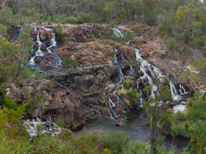
Broken Falls is also referred to as McKenzie falls. It is a well known waterfall on the McKenzie river about 10km west of Halls Gap township. If you are coming to the Grampians, this is one of the must see locations.
Viewpoints
I have been here many times. One of those times was with the Williamstown Photography Club, and the range of viewpoints that members found of these falls was amazing, with many quite nice. It is difficult to photograph these falls from the top, as the path is to the side of the river, and then drops down to the west of the falls. The two main locations therefore are:
- At the bottom of the falls. There are many variations on this.
- From the McKenzie falls lookout. This requires taking a seperate path from the car park.
Water Flow & Conditions
Water flow depends on recent rainfall and catchment conditions. Moderate flow usually preserves rock texture while providing clear movement; after heavy rain expect spray, slippery surfaces and rapidly changing hazards.
Other Things to Look Out For
How I photographed the waterfalls
What I took - what was in my kit
I took my LowePro Backpack loaded with Canon 5DMkII body, Canon 24-105mm zoom, Manfrotto 190 Tripod, and of course a range of lens wipes, spare batteries, sunscreen and bug repellant. I tended to shoot 24-50mm
Techniques
As with any waterfall, I want to blur the water but not the surrounding vegitation. That means using a long exposure and a tripod. I could have used NR filters, but in this case I didnt. I simply changed the aperature to suit. I was already shooting at ISO 100.
Location
(Carpark) Wartook Rd, Zumsteins VIC 3401 (-37.1095, 142.4124)
Apple Map – Waterfall and Photographic Locations
This Apple Map identifies Broken Falls and five nearby Auspano photographic locations.
Photographic locations
How to Get There
I beleive that it is possible to get to Halls Gap by bus, but virtually everyone goes here by car. From Halls Gap, it is only 10k or so to drive to the McKenzie Falls car park.
Driving from the State Capital
The state capital is used as a consistent reference point. The actual route varies with the traveller's starting point, traffic, roadworks and closures. The route ends at the mapped destination and may not represent the walking track to the waterfall.
State capital to waterfall
Calculating the driving route with Apple Maps…
Distance and time are estimates and may change with conditions.
Current Access / Conditions
Information checked September 2026. The Mackenzie Falls precinct is closed to all vehicles and visitors during the current construction program. Broken Falls viewpoints associated with that precinct should be treated as unavailable until Parks Victoria announces reopening. Do not bypass barriers.
Best Time to Visit
As with any waterfall, the winter / spring post rainy period is the best as more water is likely to flow over the falls and the bush around the falls tends to be greener. During the summer months and holiday periods, Halls Gap and the Grampian are also a busy holiday area, and there is likely to be tourists near the falls or getting into your photos. For this reason, if you have to visit of a summer weekend day, I would suggest going early.
Accessibility
There is a relatively flat walk path around to the Lookout, however, the path to the base of the falls contains about 2 stories of stone stairs, and then some uneven ground. You dont have to be atheletic to do this, but you certainly should not attempt this with crutches or a wheelchair.
Nearby Locations
The Grampians are a wonderful holiday destination, because there are so many sites to see and photograph here. There are other waterfalls (Fish Falls, Splitter Falls and my favourite Silverband Falls) and there are several great lookouts: the Pinnacle, teh Balconies, Reeds Lookout, Boroka Lookout. Other photographic highlights include Mount Wiliam and the Grand Canyon (a slit in the rock, not a 'grand' canyon by any means, but still pretty.)
Nearby Auspano pages
- Boroka Lookout — approximately 8 km in a straight line; road distance may be considerably longer.
- Horsham Silo Art — approximately 49 km in a straight line; road distance may be considerably longer.
- Murtoa Stick Shed and Silo — approximately 54 km in a straight line; road distance may be considerably longer.
- Little Desert National Park — approximately 76 km in a straight line; road distance may be considerably longer.
- Dimboola Street Art — approximately 81 km in a straight line; road distance may be considerably longer.
Nearby Auspano pages
- Boroka Lookout — approximately 8 km in a straight line; road distance may be considerably longer.
- Horsham Silo Art — approximately 49 km in a straight line; road distance may be considerably longer.
- Murtoa Stick Shed and Silo — approximately 54 km in a straight line; road distance may be considerably longer.
- Little Desert National Park — approximately 76 km in a straight line; road distance may be considerably longer.
- Dimboola Street Art — approximately 81 km in a straight line; road distance may be considerably longer.
Where to Stay
As a holiday destination, Halls Gap, and other areas in the Grampians have lots of accomodation options. Camping is by far the most popular option. We have stayed here in tents, the Breeze Holiday Park, (what is now) the Halls Gap Tavern, and two of the local motels. All worked for us. There is plenty of shopping in town, and just out of town is the Halls Gap Hotel Resturant, which is definitely our favourite place to eat.
Photography Recommendations
recommendations XX
Photographing Moving Water
Compare several shutter speeds rather than assuming the longest exposure is best. Begin around 1/4 second, one second and several seconds, checking highlights and fine water texture after each change.
Suggested Photographic Sequence
Work through the location in an order that makes the best use of changing light and conditions.
How Long Should a Photographer Stay?
Allow enough time to photograph the location in more than one light or weather condition where practical.
My Priority Photographs
Use this section for the practical photographic shot list for the location.
Waterfall Information
| Waterfall | Broken Falls |
|---|---|
| Coordinates | -37.10950, 142.41240 |
| Flow | Rainfall dependent |
| Recommended light | Overcast or soft light |